
Beyond the Border: Plans for v0.3 and the World Map
Every nation in National Transit has had neighbours from the start. You can see them on the macro map, pale shapes past the border line. But so far they have only been scenery. No road leads anywhere across that line, no train crosses it, and every passenger and every tonne of freight in the game begins and ends inside your own country.
We want to change that in v0.3.
You can try the world map prototype in your browser: zoom in and drag around the same world shown in this post.
From v0.1 to v0.2, and now outward
v0.1 was about connecting a nation. v0.2 took you down into its cities with the City Map, and since then you have been able to zoom from a whole country to a single street corner. What you still cannot do is zoom out.
That is the next step on the road we laid out when National Transit entered Early Access. Our Early Access notes list what the full release will add, and one line reads: “International trade and transport — connecting your nation with the wider world, in a form we’re still exploring.” The same notes promise “a more sophisticated demand model”, and say that major new systems will be shared with the community before development begins, which is why we are writing this now. In v0.3, demand will cross the border, and you will build the transport that carries it.
Why the world, and why now
The border is a dead end. Players build expressways to the edge of the country and stop there, because the neighbours are drawn on the map but do not exist in the game.
Some parts of the game are also bent around the missing world. Ports are the clearest case. When we tuned port capacity, we could only size it for domestic coastal traffic, because that is all the game has. A real country’s largest ports mostly exist because of foreign trade, and at the moment ours cannot.
And players have asked where their country actually is. Right now the game has no answer.
The idea: one more layer on top
The plan for v0.3 is a world map that sits above the national map, the same way the City Map sits below it:
World map → National map → City MapThe national map and the City Map stay exactly as they are. The world map only reads from them.
A whole world of countries
The world is generated fresh for every game, like everything else in National Transit, and it is entirely fictional. You will not find Paris or London. It is a full world all the same: countries spread over continents and islands, most of the land at low and middle latitudes, and less of it near the poles.
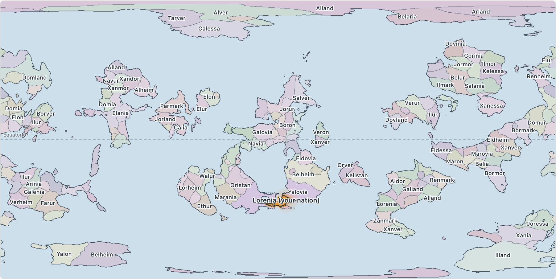
The world map at full zoom-out. It shows land, sea and borders only, with no terrain, and at this scale only country names. Your nation (orange, with a soft glow) is placed where its own coastline fits the world best. The dashed line is the equator.
Detail depends on distance. Countries that share a border with you get the most: eight to fifteen cities each. Countries within a few thousand kilometres get three to five, and distant ones get one or two, usually a capital and a port. Foreign borders, cities and names are fixed by the seed, and you cannot edit them.
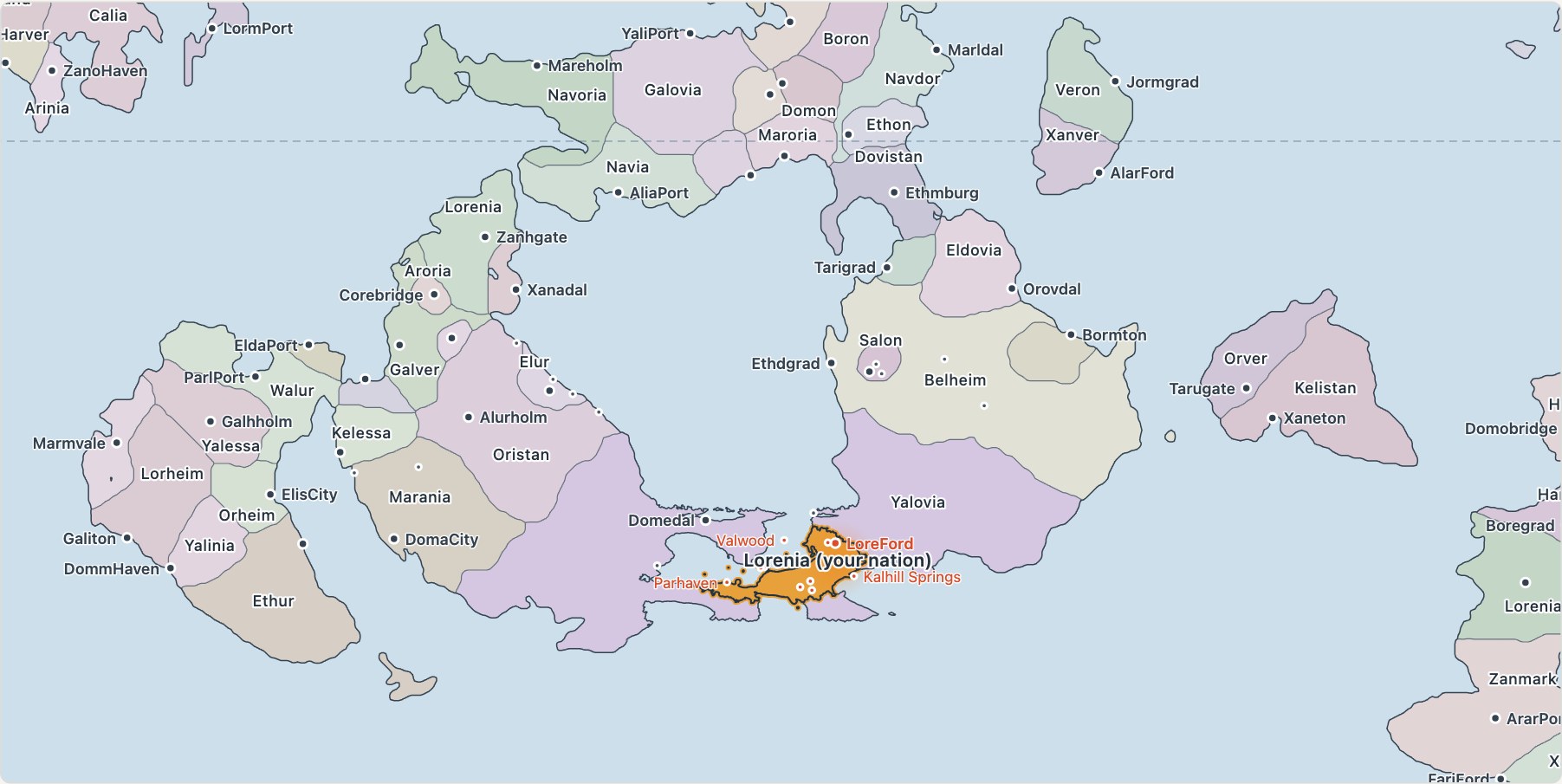
Zooming in brings in capitals and major cities, and further in, all of them. Your own settlements (in red) are the same settlements from your national map, in the same places with the same names. The world map only shows your large towns and the ones with international connections.
Foreign countries with their own economies
Each country has a population and a GDP, and so a GDP per head. Across the world these follow a log-normal spread, the same shape real countries have: most are small or middling, and a few are very large. They also change over time. Poorer countries tend to catch up, growth rises and falls in cycles, and now and then there is a crisis. None of this is written into your save file. It is all worked out again from the seed and the date, so any year you look back at shows the same figures.
These numbers will not flow into your own GDP. They are there to decide how much a foreign country wants to trade and travel with you once international connections exist.
Seeing your connections
The world map will also have a transport view. It shows the same map without country names, with the major cities of the world and the routes that leave your nation:
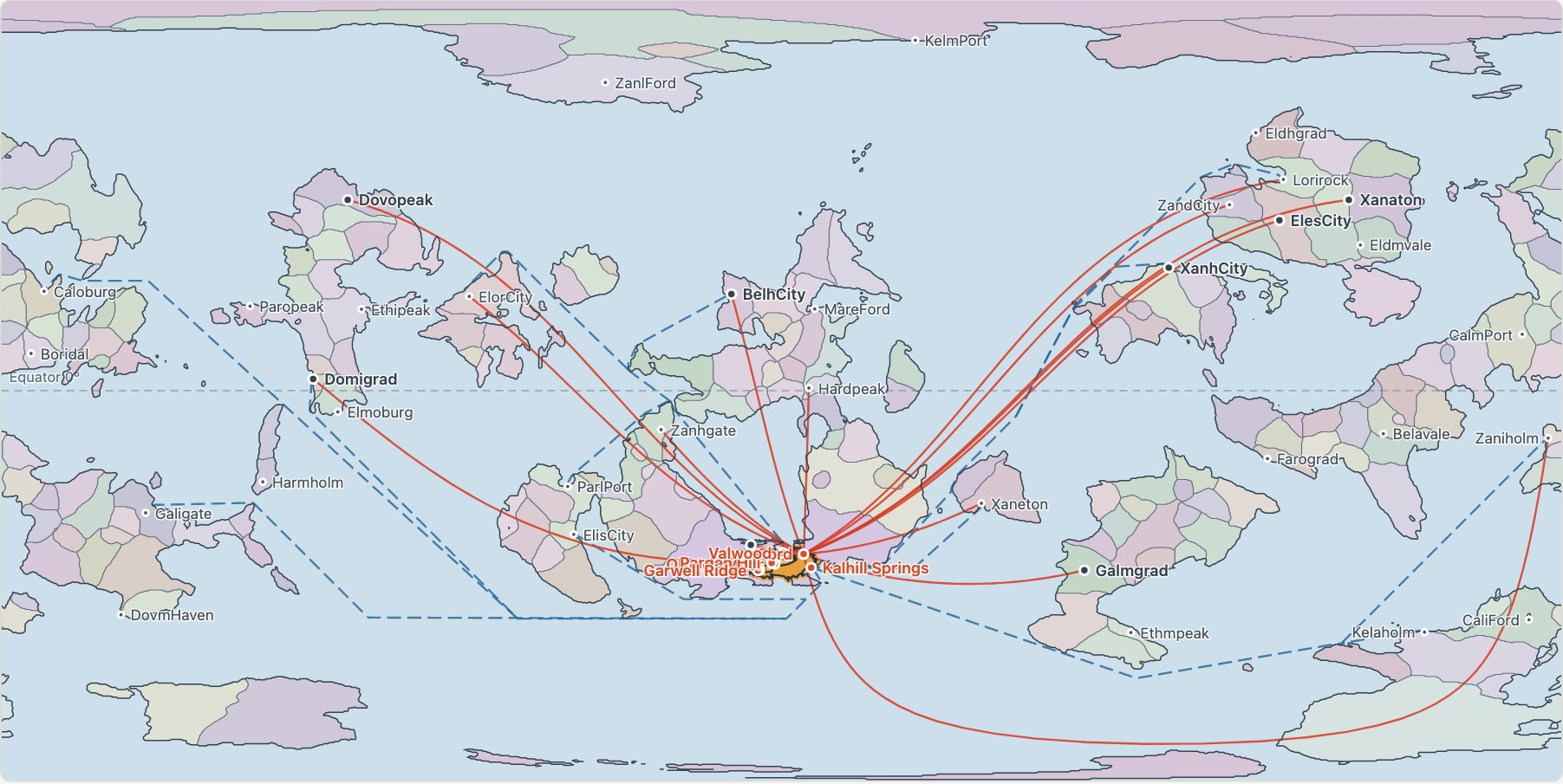
The transport view. Red lines are air routes, which fly great circles. Dashed blue lines are sea lanes, which have to find their way through open water, so they go around continents. In this prototype the routes are only examples. Which ones you can open, and what they carry, is exactly what v0.3 has to design.
The region around you
Between the whole world and your national map there is a regional view. Inside the dashed frame is your real national map, with every settlement, and outside it the world carries on without a visible seam.
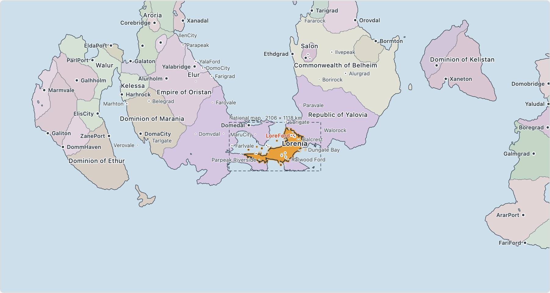
The regional view. Inside the frame is the actual national map, outside it the generated world. Joining the two cleanly took more work than anything else in the prototype. The national map has its own coastline, its own neighbours and its own islands, and none of it can be allowed to break at the frame.
You can try the prototype yourself: zoom and drag all three views of this world in your browser.
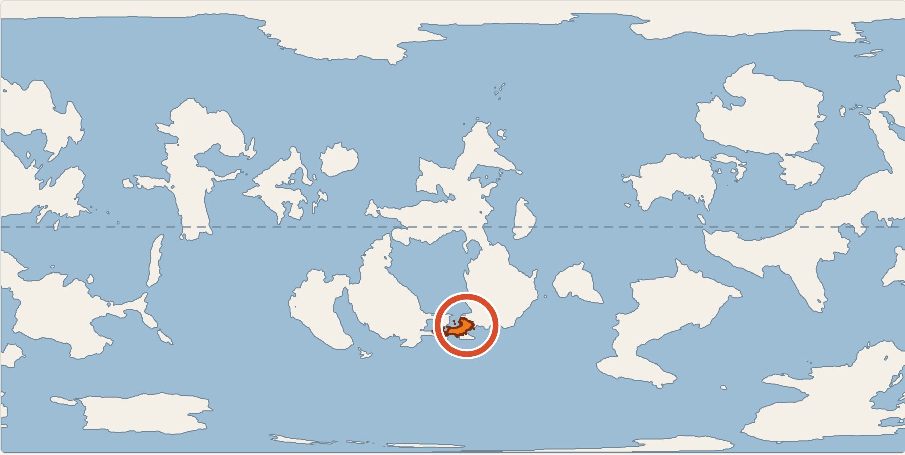
And in a corner of the national map there will be a small locator, so you always know where in the world you are:
Cross-border demand, and the transport to carry it
The main change in v0.3 is international demand: people and goods that want to travel between your cities and cities abroad. Today every trip in the game starts and ends inside your country. In v0.3 a foreign country will generate demand to and from your nation according to its size, its wealth and how far away it is, and that demand will need a way across the border. The world map comes first because everything else depends on it. After that, in rough order:
- International and intercontinental air routes. Pick a foreign city as the other end of a route. Distance is real now, because the other city has a real position.
- Border crossings. You build your road or railway up to the border; the neighbour’s side is already there. Crossings are fixed points along the border (a mountain pass, a river valley, a coastal plain), so choosing which one to develop becomes a real decision.
- International sea routes and ports, which also give ports a reason to be large.
- Trade agreements and tariffs, as policies that change how much a given country trades with you.
International trips will join the same choice your travellers already make at home: road, rail, air or sea, with feeders to the airport and the port. So an international airport or a border crossing is only useful if your domestic network can get people and freight to it. Foreign countries do not get their own transport simulation; they add demand from outside your borders, and new places for your network to reach.
Where development stands
We have a direction, and a first proof of concept. This is a design and a working prototype, not yet a feature. The images in this post come from that prototype, run on a real game map (seed 78208) with the game’s own generators for the national map and its settlements. It has shown us that:
- Generating a whole world adds only a few seconds to starting a new game, and it only happens once.
- A national map can be placed into a generated world with no visible join, whether the nation is an island, landlocked or very large.
- Foreign economies can keep a realistic spread over decades of simulated growth.
Names are still placeholders, and you will spot some repeats in the images. We will expand the name vocabulary a lot, and in all 11 languages the game supports, foreign places will get names that sound properly foreign in your own language, so the world around your nation feels more like a real one.
What happens next
The map was the easy part. The work ahead is the economics: how international demand is modelled and what it responds to; how fares, handling fees, border costs and tariffs work; and how all of it fits together with your nation’s own economy and demand simulation, so that opening a border crossing or an international route changes what happens at home in a way that is fair and makes sense. That is the stage we are moving into now, and it will take most of the time.
We are aiming to have v0.3 ready before December 2026. We will share more as the pieces take shape, and as always we would like to hear what you want to see beyond your borders.